Boulder’s View Of Hurricane Helene: Weather Maps Are A Storm’s Roadmap
Boulder is watching Hurricane Helene as it progresses inland after making landfall in Florida’s Big Bend region. It reached Category 4 status with wind speeds of up to 140 mph and more, causing significant storm surges and catastrophic flooding along the Florida coast. The impact has already been severe, with flooding expected to extend into Georgia and the Carolinas. The water is still rising. There are warnings of long-lasting power outages, flash flooding, and possible landslides in the southern Appalachians due to the storm’s intensity. Despite weakening as it moves inland, Helene is expected to cause dangerous conditions for several more days at a minimum. “Appalachian” is pronounced “app a latch ian.” NOT “app a lay chian.” Appalachia is a region that covers several states. Think “Apalachicola” and not “apa LAY chicola.”
In addition to being beautiful art, and in spite of the devastation represented, what do weather maps of hurricanes actually show? What is being mapped?
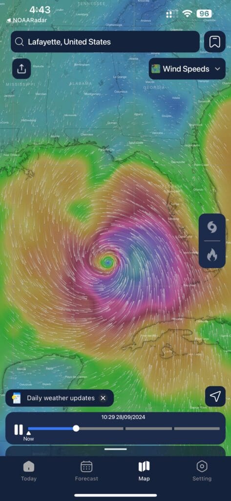
This is Helene with its eye due West of Florida. The immense storm is rotating counter-clockwise around the eye. Hurricanes in the Northern Hemisphere always rotate counter-clockwise due the the Coriolis effect. The weather map is showing us the direction of the winds and shows that the center of the storm has already passed over Key West. We can see that the high winds cover a sizable portion of the Gulf. What does the map show besides the wind directions and the location of the storm and its eye, its center?
The eye itself is a circle of calm surrounded by the eyewall. While the hurricane rages on both sides of the circle, the center area is frequently calm and clear. This storm is well organized. That refers to the uniform nature of the giant swirl of the storm. The wind is generally moving in a consistent regular pattern. It does not appear to be random areas of wind and rain, but has a clear distinct pattern.
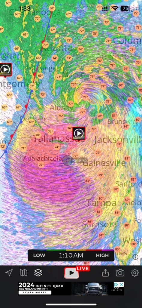
Hurricane Helene Shortly After Landfall. The Eye Is Already Over The Tallahassee Area
What are we seeing beyond the large rotating storm and its location? We pay so much attention to the eye since the highest winds tend to be found circling close to the eye. Here, the eye is already over land.
Key significant information shown on the map includes temperature, wind patterns, and storm movement.
Here’s a breakdown:
– Colors: Different colors represent wind intensity and temperature.
– Purple and red areas indicate the highest wind speeds, typically found near the hurricane’s eyewall.
– Green, yellow, and blue signify weaker wind speeds, moving outward from the storm center.
– Numbers: The orange circles show surface temperatures in Fahrenheit across various locations, like Jacksonville and Tampa. Water surface temperatures are significant since the building and diminishing of the storm is heavily influenced by the surface temperature of the water.
– Storm Path: The swirling wind patterns around the storm’s eye near Apalachicola show the cyclonic motion of the hurricane, tracking its movement. The speed at which the storm moves has a significant impact on just how much rain falls. The slower the storm, the more rain that falls in the area under the storm clouds. Here, the winds are much higher on Eastern side of the eye, and are not evenly present around the storm.
This combination of data illustrates Hurricane Helene’s current impact and trajectory, highlighting areas of intense wind and the temperature in affected regions.
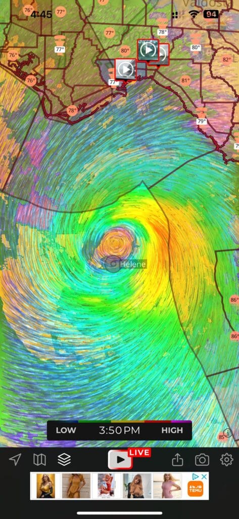
This variation in weather mapping clearly shows the huge eye in the center of the storm. Let’s take a quick look at the meaning of the various categories of hurricanes ranging from “Cat One,” the mildest, to “Cat Five,” the highest winds.
Hurricanes are classified into five categories based on their wind speeds using the Saffir-Simpson Hurricane Wind Scale:
– Category 1: Wind speeds of 74 to 95 mph (119 to 153 km/h)
– Category 2: Wind speeds of 96 to 110 mph (154 to 177 km/h)
– Category 3: Wind speeds of 111 to 129 mph (178 to 208 km/h)
– Category 4: Wind speeds of 130 to 156 mph (209 to 251 km/h)
– Category 5: Wind speeds of 157 mph or higher (252 km/h or more)
These categories help gauge the potential damage from the hurricane, with Category 5 being the most severe. Helene reached Category 4 with winds over the Gulf of Mexico in the range of 130 to 1156 mph, roughly 210 to 250 km/h or more. These are truly impressive wind speeds even for a large hurricane.
Stay safe, stay dry, and take the warnings seriously. Lives are already being lost. We can, however, do many things to minimize the loss of life. Property damage and loss of power over a vast region are harder to prevent, and hard to minimize. Survival today. Cleaning up and drying out, tomorrow.
Lenny Lensworth Frieling
Shared Knowledge is Power!